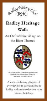
This walk around the village combines glimpses of everyday life in days gone by in Radley with an introduction to its historic buildings. Discover the village’s history by comparing old photos with what you see now. The leaflet features 24 points of interest and includes a map.
The walk has two halves, both starting at the Bowyer Arms pub. One half includes St James the Great Church and the ancient ‘Radley Oak’ in the grounds of Radley College. The other explores some of the old farmhouses and cottages in Lower Radley and takes you down to the River Thames.
The leaflet is on sale at Radley Village Shop, price £1.50, or you can download a free PDF here.
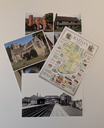
Over 500 Radley History Club postcards have sold since they went on sale in 2015. With very few left, the Club decided to produce two new designs to sit alongside the two most popular of the original designs – the Millennium Map and the group of four of Radley’s historic buildings.
The postcards cost 80 pence each from Radley Village Shop where they on sale alongside fresh stock of the Millennium Map and ‘buildings’ postcards, and residual stock of the postcards of the church in autumn and the pond. All the postcards are 6 x 4 inches in size.
One of the new postcards features colour photographs taken this year following completion of the restoration work on the exterior and interior of Radley Church. The other is a black & white archive photograph of Radley Station in 1919 – when it had staff, a signal box and other buildings, and a third platform serving the branch line to Abingdon (referred to locally as the ‘Bunk’).
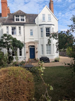
The marketing material for the 2025 sale of the top-floor flat at 75 Foxborough Road states it is part of a ‘former school conversion’. What school you may ask? The house was a school but only for a short time back in the 1940s. Living there during the mid-1940s, when it was a large semi-detached Victorian house over three floors known as East Cottage, were Stephen and Barbara Dockar Drysdale with their family. More about East Cottage
75 Foxborough Road, September 2025
Dublin-born Barbara Estelle Gordon (1912-1999) married (Joseph) Stephen Lloyd Dockar Drysdale (1911-1996) at Radley Church in April 1936. Before her marriage, Barbara had lived with her mother in a cottage in Blewbury, Oxfordshire, where she had run a small day nursery/ playgroup. At the time of her marriage, she and her mother were living at Neat Home Farm in Radley.
Barbara and Stephen started their married life at Home Farm, another of the Radley farms owned by the Dockar Drysdale family. At Home Farm, Barbara again set up a nursery for local children while Stephen ran the farm and acted as a land agent. A daughter (1937) and then a son (1938) were born at Home Farm; the family was living there when the Second World War began in September 1939.
Barbara’s ability to manage and communicate with children had been noticed by a local doctor who was aware of problems in placing evacuated children with social, emotional and behavioural issues with Radley families. He asked Barbara to take some of the youngest into her nursery school. When the school outgrew Home Farm, Barbara and Stephen moved sometime in 1943 or soon after to East Cottage. It’s not known whether they bought or rented the property, though the latter seems more likely. The nursery school children came to live there with the family, and Barbara employed teaching and domestic staff to help her. Stephen joined the Army in 1944 or 1945 and served as an officer in the Royal Army Service Corps in Egypt, Palestine and Cyprus.
Barbara’s pioneering work was recognised towards the end of the war when officials from the Home Office and the Ministry of Education approached her about setting up a special school on a more formal basis for troubled and traumatised children. With this in mind, Barbara arranged to buy an old farmhouse at Standlake in Oxfordshire, writing to Stephen to tell him what she’d done! Stephen was able to provide funds for the new school from his share of Wick Hall Estates Limited (formed in 1944 to manage the Dockar Drysdale family estate). He left active service with the Army to help Barbara run the new school at Standlake, where he was affectionately known as ‘Mr D’.
The Drysdales and their family of by now four children (two girls and two boys) moved to Standlake in 1948 to set up an independent, residential special school. The school’s name, the Mulberry Bush School, was inspired by the children drinking their morning milk under a mulberry tree at Radley. We know from various sources that the school’s name was first used for its forerunner in Radley:
Ada Kathleen Belcher, a widow aged 26, gave her address in the Radley Church Register entry for her marriage in March 1946 to Richard Lynne as the ‘Mulbury Rd School Rad’.
The Radley electoral registers for 1946, 1947 and 1948 record Barbara Dockar Drysdale’s address as ‘Mulberry Bush School’. Stephen’s name does not appear in these registers because he’s still serving with the Army. Barbara is not listed in the 1949 register, consistent with the move to Standlake.
Having set up the school at Standlake, Barbara sought to learn more about child psychoanalysis and to gain qualifications to support her new role. She studied psychotherapy at the Tavistock Clinic and the Maudsley Hospital in London, and later became a famous psychotherapist renowned for her pioneering work with troubled and traumatised young children. Today the Mulberry Bush School is a not-for-profit charity.
If you want to know more about the early years of the Mulberry Bush School, there’s a YouTube video recorded by Barbara’s daughter Sally Cooper and Sally Finch (an ex-pupil). For more about Barbara’s life, see her entry in the Mulberry Bush School Research Archive and the many obituaries published after her death in 1999.
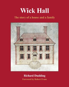
Wick Hall: the story of a house and a family is about Wick Hall in Radley near Abingdon, and the Dockar Drysdale family who purchased and then transformed it in the nineteenth century. An intriguing piece of local history, it also opens a window on wider social change. More about the book
The full programme of talks at Radley History Club’s monthly meetings from September 2025 to September 2026 is now available. View details of each talk in the Events calendar on this website.
Date
Speaker
Talk title
2025
08-Sep
Simon Wenham
More than Three Men in a Boat: the rise and fall of pleasure boating on the Thames
13-Oct
Liz Woolley
‘Some may question its flavour, but none its potency’: a history of brewing in Oxford a history of brewing in Oxford
10-Nov
Paul Booth
From Roman Britain to Early Anglo-Saxon England: archaeological evidence from Dorchester-on-Thames
2026
12-Jan
Richard Dudding
Wick Hall: the story of a house and a family
09-Feb
Steven Gunn
Everyday life and accidental death in 16th century Oxfordshire and Berkshire
09-Mar
John Lowe
‘Always Ready, Always Willing’: Fires and firefighting in the city of Oxford from 879 to 1974
13-Apr
Hubert Zawadzki
My Polish father’s experiences in WW2 from Gulag to Normandy and Scotland
11-May
Mike Hurst
Tracks to trenches
08-Jun
Stephen Wass
Garden archaeology: ‘not that kind of digging’
13-Jul
Victoria Bentata
Alice and the Dodo in Oxford
08-Sep
Melanie King
Sarah Churchill, Duchess of Marlborough: taking the waters in Bath, Scarborough and Windsor Great Park
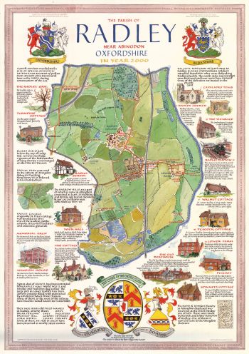
This year marks 25 years since the Millennium. To commemorate that occasion, Radley History Club commissioned the artwork to create a large, annotated colour map of Radley featuring many of the village’s historic landmarks. The map – commonly referred to as the ’Millennium Map’ – proved popular and many were sold at the time. Many past and present Radley residents have one!
There are still some left to buy at a cost of £5 (plus postage and packing). If you’d like one, please get in touch with Joyce Huddleston (chairman@radleyhistoryclub.org.uk).
Back in November 2024, one of the maps was sent (courtesy of Royal Mail) all the way to California to someone who had found details of it on this website. His name was Steve Fabes and he’d been born in Radley in 1944 during the war when his parents, refugees from London, were living in the attic flat at Lower Farm. Steve even gave his youngest son the middle name ‘Radley’. He can remember his father referring to the farmer as ‘Mr Frierson’ and thinks the family probably moved back to London in 1946. Steve still has relatives in the UK but has lived in California for over 50 years.